
It is essential to find out more about the considered territory and the actual needs of the stakeholders.
There is usually a primary driver of a change in landscape management - for example, issues with flash floods, overheated city centers, lack of groundwater, or a drastic biodiversity decrease. Also, the requirements of an individual property owner will be different from formulating and fulfilling a strategy of a local government.
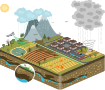
Once the details will have been clarified is the first step aerial analysis of the area. We use drones, which are equipped with special data collection technology, along with additional data sources.
Delivery: the data collection will start in the timeframe of several weeks after the agreed terms. The aerial data collection is dependent on the current weather conditions and local permits, hence it will require careful planning.

The collected data is processed and analyzed. This unlocks the true potential behind our multidisciplinary team which will help to formulate the strategy for the considered territory and the requirements to be addressed.
Our artificial intelligence helps with data processing, e.g. surface recognition allows very precise models and calculations.
The data interpretation includes the suggested types of and actual approximate placement of the rainwater retention measures within the considered territory. The expert team develops a strategy for landscape development, which not only reflects the data but is also driven by the primary stakeholder motivational factors. The strategy encompasses a variety of other adaptation measures.
Delivery: we are working on BIG data, hence please allow several weeks to have the data processed and interpreted.

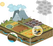
The implementation project is based on the customized territory development strategy and inputs collected from the relevant stakeholders.
The project documentation covers a detailed analysis of the micro-river basins. The micro-basins are assigned priorities individually according to the local environment and technical details are provided for each adaptation and rainwater retention measure to be implemented. The most appropriate water retention measures are selected and combined from an existing catalog of over 5000 entries. Each water retention measure type is documented in detail.
Delivery: the terms are to be agreed individually based on complexity of the territory

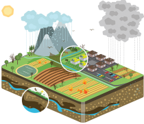
We provide supervision during implementations to ensure the newly implemented rainwater water retention and other adaptation measures are going to be effective and functional.
It is optional and recommended to have the actual implementation done by an independent local company. If you need a recommendation, just drop us a note.
Delivery: during project implementation

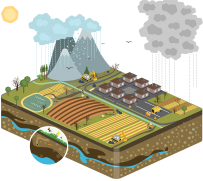
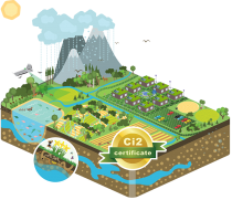
The multidimensional climate impact index (Ci2) assesses compliance of the territory to the best practice of landscape management.
The goal of this step is to ensure that the implementation of the project was done correctly and that the adaptation and rainwater retention measures actually work as designed.
Aerial monitoring of the territory leveraging a drone with custom-built sensors is a prerequisite for the assessment. Our proprietary algorithm evaluates the monitored parameters, quantifies each section of the territory, and even indicates areas of future improvements.
The certification is valid for four years. The territory is re-assessed after this period to ensure that the performance of the implemented measures did not deteriorate over time and the landscape is regenerating over time.
Delivery: Please allow several weeks after monitoring takes place for the delivery, depending on the size of the monitored area.